Tuesday, June 30, 2015

Clark Lake: Great Blue Herons Up Close


6 April 2015

Lake #20         Clark Lake, Clark Lake Wildlife Area, Clark County

Tiny 102-acre Clark Lake is often overlooked due to its nearby, much bigger neighbor, 2120-acre C. J. Brown Reservoir located in Buck Creek State Park. When my daughter and I were heading to Clark Lake from Eastwood Lake in Dayton, we accidentally ended up at C.J. Brown Reservoir. Apparently, even the GPS was out to over look poor Clark Lake. The gray clouds that had been hovering over us at Eastwood Lake had followed us to Clark Lake, but we were determined to paddle just the same.

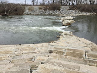
Clark Lake sits in the quiet countryside, approximately 8 miles east of Springfield, northeast of Harmony, off U.S. Route 40. Clark Lake is an older lake; the lake was completely filled in 1958. Clark Lake is a headwater impoundment of Sinking Creek, which feeds it from its northeast tip. The earthen fill dam is centrally located on the western shore of the lake. 
Clark Lake Dam From a Distance
Clark Lake Dam
The shallow lake, average depth 2 to 5 feet, has a maximum depth of 6 feet near the dam. The lake’s sand and gravel bottom prevented it from being deepened. The fingers on the eastern side of the lake are shallow and heavily vegetated in areas.

There is a 10 horsepower motor restriction on the lake. The boat ramp, parking for trailers, and port a john are located on the southern tip of the lake off of Vernon-Ashbury Road and Old Columbus Road. U.S. 40 and I-70 are only 2 miles away via Bowman Road.
Clark Lake Boat Ramp
There is also carry-in boat launching from the parking areas located on the eastern side of the lake, simply continue on the access road past the boat ramp parking area.

It is pretty easy to find a paddling partner on pretty sunny days, not so easy on the cold dreary ones. Based upon previous outings, I thought my daughter Anna might have been bitten by the paddling bug. Today's paddle would show me that I had passed on my love of paddling to her. It is something special to see your child loving something that you feel passionate about.
My Daughter Leads the Way North Towards the Dam
Duck Blind on the West Side of Lake on the Way to Dam
Anna and I were able to get the closest I have been to Great Blue Herons while on the water. It started lightly raining shortly after we put in; perhaps the rain masked our smell and made us seem less threatening to the birds.
Anna Spotting a Great Blue Heron
Anna Getting Closer to the Great Blue Heron
Great Blue Heron
Great Blue Heron Finally Got Tired of Our Company
After spending time with the Great Blue Heron, we headed east to the opposite side of the lake to explore its arms and fingers. I always prefer a lake's fingers to its wide open areas. 
Heading Into Northeast Finger
My Daughter Loves Exploring Fingers Just Like Me
Anna and I discovered more Great Blue Herons here. It was so peaceful to watch the herons and listen to the songbirds. 
It started to rain heavily and I thought my daughter would want to call it a day, but she wanted to keep on paddling. She said, "We won't melt." The baby duck for today was a purple fairy duck. We decided to name the duck Glinda, for the good witch of Oz, since she wouldn't melt either.
Baby Duck Glinda Enjoying the Rain
Baby Duck Glinda of Oz
After letting Glinda take a swim, we headed to the most northern finger of the lake. This area was narrow with heavy vegetation. I saw a Red-Winged Blackbird which made me happy. Seeing the bird gave me hope that spring was really on its way. It was fun to watch him singing and made me thankful that my daughter and I had decided to stay out longer on the lake.
Red-Winged Blackbird in the Marshes
 A couple times I told my daughter that we were at the end of the line and she would hunt until she could find a way to go a little farther. She was eager to explore and find the hidden places, just like me. When my husband is my paddling companion, he is usually telling me that we can't go any farther and I am the one pushing a little bit more.
Although today was cold, wet, and dreary, it was a lovely paddle. Sharing the experience with my daughter made it even better. To quote Albert Schweitzer, "Happiness is the only thing that multiplies when you share it."

May all your roads end in water,

Mama Duck Mona


Thursday, June 25, 2015

Eastwood Lake: Water Focused Metro Park

April 6, 2015

Lake #19    Eastwood Lake, Eastwood Metropark, Montgomery County

My daughter is on spring break this week and is going to join me on my BHAG; unfortunately, Ohio is predicted to have thunderstorms all week. Today, only rain is in the forecast so we are heading to Dayton to check out Eastwood Metropark. The 437-acre park offers a variety of water focused recreational opportunities, including boating on the 185-acre Eastwood Lake.
Eastwood Lake
The lake is the feeding ground for a pair of bald eagles, christened Jim and Cindy, who have nested across the road from the lake at the City of Dayton Mad River Well Field since 2009.
Maybe You Will See Jim and Cindy
The entrance to Eastwood Lake is at 1401 Harshman Road. There are two put-ins for kayaks/canoes. The first is to your right just after entering the park.
Kayak Put-in

First Put-in As You Enter the Park
There are no facilities at this location and trailer parking is not permitted. A short distance down the road, also on your right, is the main boat ramp. 
Eastwood Lake Main Boat Ramp

Here you will find restrooms with running water and ample parking (this is the only location where trailers are permitted to park).
Restroom With Running Water
Given how close the two locations are to one another, I see no 
reason to use the first put-in. 


Mile long Eastwood Lake was completed in 1972 with the goals of providing water recreation and protecting the Dayton water supply. The lake was a by-product of gravel mining operations by the American Aggregate Corporation. Mad River feeds Eastwood Lake and neighboring Blue Lake and the lagoons. There is a small amount of vegetation around the lake and a few scattered trees. State Route 4 runs along the entire north side of the lake and downtown Dayton is visible from the lake to the west. Overall, it is a more utilitarian lake than a pretty one.
Heading East From Boat Ramp
Heading East Towards Harshman Road
Gray, Choppy Day at Eastwood Lake
My Daughter Anna Keeping Me Company on the Water 
Heading West
Paddling West With Downtown Dayton in the Background
Kayaks and canoes are allowed to use the lake on any day, but other types of watercraft are restricted based on odd/even days. Powerboats, fishing boats, and water skiers are permitted on the lake on even-numbered days of the month. There is a 35-mile per hour speed limit. Sailboats and fishing boats at idle speed are permitted on odd days. I was there on a rainy, even day and the only other boat on the lake was a fishing boat.
Boating Restrictions Based on Days
Unfortunately, I did not get to see the resident eagles while I was kayaking, but I did see a pair of nesting Mallard ducks and a pair of American Coots.
Nesting Mallards
American Coots
I didn’t come up for a name for my neon baby duck while I was out on the water. I try to name the ducks based on something special about the lake I am on and I wasn’t channeling anything special about Eastwood Lake. I ended up naming the baby duck for this lake Hurley; in honor of my favorite character from the television show Lost. I misplaced Hurley while I was putting my gear away and thought I had “lost” him, but he magically reappeared later.
Baby Duck Hurley
Baby Duck Hurley Before He Was 'Lost"
Blue Lake lies just south of Eastwood Lake. It would be a great place to take a small child kayaking for the first time.
Kid Sized Blue Lake
South of Blue Lake is the Mad River and its kayak access and play spot.
Kayak Mad River Trail North Access
Path to Mad River From North Side
Entering the Class II Mad River here provides a 4.5 mile uninterrupted paddle to RiverScape MetroPark in downtown Dayton. There is parking for a couple cars on the north side of Mad River, but the main parking is located on the south side. To access the south side of Mad River and the lagoons, you have to drive back out to the main road, Harshman, turn right and reenter the park at 1385.
River Launch at Mad River

Mad River Looking East From Put-in
Mad River Put-in
I would have loved to paddle the lagoons; unfortunately, the water level was down due to construction taking place. The lagoon is very picturesque and would have been a much nicer paddle than the one I had on Eastwood Lake.
One of the Bridges Crossing the Lagoon
Eastwood MetroPark Lagoon
Kayak/Canoe Put-in at the Lagoon
The park surrounding the lagoon and the river has hiking and biking trails, a playground, and several pretty picnic areas. My advice is to skip Eastwood Lake and spend all your time on Mad River or relaxing on the lagoon.

May all your roads end in water,

Mama Duck Mona


Wednesday, June 24, 2015

Stonelick Lake: I Get to See an Animal That I Have Never Seen in the Wild Before


5 April 2015

Lake #18    Stonelick Lake, Stonelick State Park, Clermont County

This was my fifth and last lake of the three day Easter weekend. Stonelick Lake is just 22 miles from Cincinnati, but it feels more remote. I only saw three other people while I was there. The 200-acre lake is located within the 1,058-acre Stonelick State Park. The park office is located at 2895 Lake Drive at Newtonville Road. The park has a 500-foot public sand swimming beach; 5 miles of nature trails; 18 miles of mountain biking trails, and camping facilities.
Stonelick Lake Swimming Beach
There are 108 electric campsites, 6 non-electric, and 1 deluxe camper cabin. The camp area is located on the eastern side of the lake and is typical for a small state park. When I was driving on Woodville Pike to go check out the campground, I passed a sign that said “Group Camping” which was placed in front of a cemetery (the turn off for the primitive group campsite is right past the cemetery). I so wish I had turned around and gone back and taken a photo of the sign with its background. Now every time my husband and I pass a cemetery, we say “Look, group camping.”  Yes, I agree, there is something wrong with us. If you visit the lake, I would love a photo so I can post it on the blog.

A dam was built across Stonelick Creek in 1950 to provide a wildlife area for sportsmen. The dam is located on the west side of the lake on Newtonville Road. In the early 1990s, the lake was dredged to restore the contamination levels of the lake from a waste water leak. The lake hasn't experienced any difficulties since then.

Stonelick Lake Dam
Stonelick Dam Newtonville Road
Stonelick Lake Spillway, Stonelick Creek
Stonelick Lake allows boats with electric motors only and has one boat ramp on the northwest corner of the lake off of Lair Road. As you can see, Stonelick Lake was experiencing high water levels like rest of southwest Ohio, which caused it to have very muddy water.
Stonelick Lake Boat Ramp
View From Boat Ramp Looking East
View From Boat Ramp Looking South
There are no facilities at the boat launch, but there are restrooms at the swimming beach and campgrounds. There is a convenience store located shouting distance from the boat launch parking lot.
Convenience Store on Lair Road, Walking Distance to Boat Ramp
After putting in, I headed south to go check out the dam from the water. Like many other small lake dams in Ohio, Stonelick Lake Dam has no warning buoys or roping to stop a boater from going over the spillway.
Turtles on the Way to the Dam
Stonelick Lake Dam
After checking out the dam, I headed northeast towards the swimming beach.
Northeast Towards Swimming Beach
Picnic Area Off of Lake Drive in the Distance
Stonelick Lake Swimming Beach
After checking out the swimming beach, I headed to the far southeastern corner of the lake to check out the finger where Stonelick Creek feeds into the lake.
Heading East Towards Camp Area
I am all about nooks, crannies, fingers, and arms, whatever you want to call the little places jutting off lakes. The small finger where Stonelick Creek feeds into the lake seemed much larger than what is indicated on the park map. Perhaps, it was much larger due to the heavy rainfall the region had been experiencing.
Heading Into Southeast Finger
Finger Seems Much Larger Than What is on the Map
  As I was exploring this area I had the special treat of seeing my first river otter in the wild. I have always loved watching the river otters at the Columbus Zoo and Aquarium, but seeing one in the wild was so much better. Ohio river otters were extirpated in the early 1900s. In 1986, the Ohio Department of Natural Resources started a 7-year project to reintroduce river otters to the state. Since then, river otters have been sighted in two-thirds of Ohio’s counties. It was just about dusk when I spotted the otter. I tried my best to get a photo, but the otter was too fast for me. He swam under my husband’s kayak and circled back around to enter his bank den. If someone had been video taping me trying to get a photo of the otter, it would be hilarious to watch.
The Brown Shape in the Middle is a River Otter, I Promise He Really is There
Stonelick Lake's baby duck is a sheep (in keeping with my Easter theme weekend); I ran out of Easter bunny ducks. In honor of the otter, I am naming him Tarka. Henry Williamson wrote a book called Tarka in 1927, the name means little water wanderer.
Stonelick Lake Baby Duck Tarka

After seeing the otter, I knew that was the highlight of the lake and a sign to call it a day. The joy and excitement I felt in seeing my very first river otter in the wild is the reason I am doing this BHAG. Happiness can't be planned. It must simply be experienced.
Heading West to Boat Ramp and the End of a Day Kayaking
May all your roads end in water,
Mama Duck Mona