Saturday, April 25, 2015

Winton Lake: A Day of Firsts


5 April 2015

Lake #17    Winton Lake, Winton Woods, Hamilton County

Easter morning found me 20 minutes north of downtown Cincinnati within the 2700-acre Winton Woods Park. Winton Woods is one of Cincinnati’s biggest and most visited parks. It is located at 10245 Winton Road. The 156-acre Winton Lake is among its many features. The lake was created in 1952 by damming the West Fork of Mill Creek. Originally, the lake was only open to the park system’s rental fleet of boats. It is now open to private kayak and canoe paddlers as well. Like the rest of the lakes in southwestern Ohio that I had visited over the weekend, Winton Lake was experiencing high water levels. You could paddle up to benches in the lake and take a seat. 
Winton Lake, a "Little" Flooded  
Winton Lake Harbor 


This Female Mallard Was Enjoying the High Water
This is really a nice metropolitan park. I wish Columbus had something similar. It costs $3 per day or $10 annually to park, but there is no additional fee to use the lake. The park has several boats for rent to compete with your space on the lake. Happily, the boathouse was not open when I was there. The fleet of pedal boats lined up at the boathouse had the look of an amusement park ride. The park also has rowboats, pontoon boats, kayaks, canoes, motorboats, and stand-up paddleboards for rent. A large pontoon boat, called the Harbor Point Winton Queen, takes visitors on tours of the lake (I can’t even imagine how much fun that must be, yes I am being sarcastic).
Winton Woods Boathouse
Rental Pedal Boats and Pontoon Boats Waiting for Warm Weather
Motorboats for Rent at Winton Lake
Canoes and Kayaks Ready for Action
Harbor Point Winton Queen, Not Looking Too Queenly
At Winton Harbor there are restrooms with running water but they were under repair the day I was there; portable toilets were set up for use in the parking lot. Two really nice playgrounds are located at Harbor Point; one is a wet playground called Parky’s Ark (I was tempted to play on it even without the water). There is a paved hiking/biking trail and you can rent a bike during the season. In addition, there are basketball courts, a snack bar with outdoor dining, and fishing from the pier.
Winton Woods Harbor Central Overlook
Parky's Ark Wet Playground
The Winton Woods Campground is open March 6th through November 29th. I was surprised at how many people were camping Easter weekend. The campground has 123 sites, including: 25 RV back-in sites, 12 RV pull-through sites, 68 sites with 30-amp hookups, 10 basic cabins, and 8 large deluxe cabins. The area is wooded and offers more privacy than many campgrounds. Several campsites are located at the water’s edge. As a special bonus to paddlers, the campground has its own kayak/canoe launch.
Winton Woods Campground in the Background 
My Paddling Buddy and Hubby in Front of the Campground
Winton Woods Campground Boat Launch Area
As I was there on Easter morning, there was plenty of parking and room to turn around my trailer. In the summer, parking might be a challenge. The launch ramp is located east of the harbor. There was a mother and daughter kayak duo exiting the lake when I put in. While I kayaked, there were no other boaters out on the lake. It was only 9:30 a.m. on Easter morning. For all I know, it could be a zoo on any other day. From the boat launch, I paddled east heading towards the campground. There is a pedestrian bridge to paddle under before reaching the campsite. The support pillars made for a little paddling diversion.
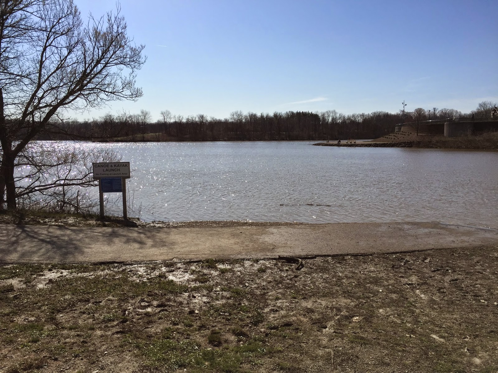
Winton Lake Canoe and Kayak Boat Ramp 
Winton Lake Boat Ramp Viewed From Harbor Point
Harbor Point 
Heading East Away From Winton Harbor 
Walking Trail Bridge
Paddling Under the Bridge
I then checked out the little finger, south of the campground. You never know what you might find in the little nooks and crannies of lakes. What I found this day were lots and lots of turtles. Along the banks, several turtles were out in rows on logs basking in the sun. It was only about 55 degrees out, but like the turtles I felt the warmth of the sun and its promise that spring was finally here. These were the first turtles I have seen this spring. I believe the turtles I saw were Midland Painted turtles; although, I did not get close enough to see their red markings. In their honor, I named the Easter “bunny” duck for today “Honu” which means sea turtle in Hawaiian.
Six Little Turtles
Five Little Turtles
Four Little Turtles 
Three Little Turtles
Two Little Turtles
One Brave Little Turtle
Winton Lake Baby Duck "Honu" 
Paddling northeast towards the dam, I passed an island. I christened it Goose Island, because of the several Canadian Geese nesting there. I found an Easter egg hanging on the edge of the island in some exposed tree roots. In all my days of paddling, I have never found an egg before. It seems quite a strange coincidence that I found my first and only egg on Easter morning. As I paddled away, I felt sad for the goose that would never exist but then I remembered how annoying Canadian Geese can be  and didn't feel so bad anymore.
Goose Island (I Don't Think It Has a Real Name)
Nesting In Progress
I Found an Easter Egg 
Many lakes that I have paddled have had no buoys or warnings located near their dam spillways, even in situations where a paddler would be at risk of serious injury or death if they continued on. Winton Lake has gone to the opposite extreme. The dam area is roped off with what look like numerous giant pool noodles. I don’t think a kayak could even make it through the small spillway. This is an indication to me that the lake sees a lot of inexperienced paddlers normally. After paddling to the east end of the lake, I turned around and went to check out the area north of the campground.
Winton Lake Dam
Beware: Giant Pool Noodles
The campground itself looks nice and the boat ramp serviceable, but the lake around the north shore is not attractive. Construction work is being done, running a very large sewage pipe over the lake. I did get to see my first wildflowers of the season growing along the bank, so I was content. After this, it was time to start paddling back to the put in location. I followed a Snow Goose and a Mallard duck, and we headed west.
Sewage Pipe Construction North of Campground
Marsh Marigolds Growing Along Winton Lake
Heading West Towards the Foot Bridge
A Snow Goose and Mallard Duck Lead the Way
May all your roads end in water,
Mama Duck Mona


Friday, April 17, 2015

William H. Harsha Lake: I Ace My Vessel Safety Check


4 April 2015

Lake #16    William H. Harsha Lake, East Fork State Park, Clermont County

William H. Harsha Lake (aka East Fork Lake) is located in East Fork State Park, which is one of Ohio’s largest (4,870 acres) and most visited state parks. The park is located 2 miles south of Batavia and 25 miles east of Cincinnati.  The 2,160-acre Harsha Lake is named for a popular U.S. Congressman who represented the area from 1961 to 1981. He also has a bridge named after him that spans the Ohio River, connecting Aberdeen, Ohio to Maysville, Kentucky.

The state park office is located at the south park entrance off Highway 125 at Elklick Road. In addition to the lake, the park offers: a 1,200 foot swimming beach with restrooms, changing booths, and showers; several hiking trails, including the 32 mile Steven Newman Worldwalker Perimeter Trail, which circles the park; mountain bike trails; bridle trails; a campground with over 400 electric camping sites (all allow pets), nine full-service camp sites, two cedar cabins (no pets), a beach, and a boat ramp.


Harsha Lake was the last lake in Ohio impounded by the U.S. Corps of Engineers for flood control. The U.S. Army Corps operates a visitor center at Slade Road on the western end of the lake. Harsha Lake was created in 1978 by damming the East Fork of the Little Miami River and the two feeder creeks: Poplar and Cloverlick. It is the 2nd deepest lake in Ohio. The water level at the dam is normally 113 feet, with the lake having average water depths of 60 to 80 feet. I swear you can feel that depth below you when you are paddling. The lake feels heavy. The day I was there, the lake was experiencing high water levels like the other lakes I had visited that weekend. The lake has six boat launch areas and allows unlimited horsepower.

When I first arrived at the lake, I went to the North Shore Boat Ramp located off Old Route 32, the same road used to access the campground. The sign “Road Ends in Water” lets you know you are headed the correct way. I always get excited when I see one of these signs. There was a huge parking lot with plenty of room for turning around a trailer, pull through parking spaces, and restrooms with running water (which were still locked for the winter). You can get a view of the dam from this location. The earthen dam is 200 feet high and 1,450 feet long.
This Sign Always Brings a Smile to My Face
Road Down to North Shore Boat Ramp 
Harsha Lake Dam
I next backtracked up Park Road #5 to the campground entrance, with the intention of checking out the Campground Boat Ramp. Although the ramp is located within the campgrounds, anyone is permitted to use it. I was unable to scope out the boat ramp because high water made the road back to the ramp impassable. I did visit the ramp later in the day from the water. I didn’t make it to three other boat ramps: the Tunnel Mill Boat Ramp located on the far northeast edge, off Twin Bridges Road; the Reisinger Road Boat Ramp located in the far southeastern corner, off Reisinger and Macedonia Roads; and the Dam Boat Ramp, located off Slade Road and State Route 222.
Paddling to the Campground Boat Ramp 
Campground Boat Ramp  
After my failed attempt at the campground, I headed to the Tate Boat Ramp that is located on the south shore of the lake at its skinny midpoint. The ramp is accessed off Park Road #1, which is off South Bantam Road at the park’s entrance. The United States Coast Guard Auxiliary was there conducting volunteer vessel safety checks. Vessel Examiner Lawrence Neltner and Vessel Safety Volunteer Larry Stulz explained the volunteer inspection process to me and I readily agreed to participate. The goal of the volunteer safety inspections are to make boaters aware of what requirements they should be meeting without the fear of receiving a ticket if they fail to pass. The bonus being that if you pass you get a pretty sticker for your boat and you are good to go. The vessel safety check for kayaks and canoes requires: a sound signal (whistle, horn, etc.); life jacket; good overall vessel condition, including paddle/oars; navigation lights (these are only required to be used at night or if you are in a situation where you will not be easily visible); and visual distress signals. I am happy to report that I passed with flying colors; I had every single item. “Yeah, me.” I thought that I was paddling safe but it was nice to find out for sure. There are additional open water recommendations of which I had everything but a spare paddle. I had carried an extra paddle with me in the past but had got out of the habit of taking it along. As a result of this inspection, I have started carrying it again. Now, in addition to the requirements, I meet all the recommendations as well. If you have the opportunity to have a volunteer inspection done, I urge you to do it. There is nothing to lose and you might find out that you are missing an important safety item. I named the baby duck for this lake “Coasty”, in honor of Mr. Neltner and Mr. Stulz, who were happily working on Easter weekend, and for all the other men and women of the US Coast Guard Auxiliary.
Yeah, I Aced My Safety Check
New Bling for the Kayak 
Baby Duck "Coasty"
The Tate Boat Launch area has plenty of parking and turn around room for a trailer. This boat launch area was not even half as busy as the one at North Shore. It has restrooms with running water but they were not open. There was a portable toilet available for use. The high water level of the lake was apparent at the ramp but did not cause any trouble with put in. I chose to head east; I wanted to stay away from the big open area of the west side of the lake. I also wanted to check out the campground area and see how bad the flooding was up close.
Tate Boat Ramp 
Look Closely to Find the Sidewalk 
The Light Is Not Suppose to Be in the Water 
Heading East From the Tate Boat Ramp 
Heading North Toward the Campground
Baby Duck "Coasty" Goes for a Swim With the Debris From the Heavy Rains
Baby Duck "Coasty" Back on Board After His Swim
The Finger Just West of the Campground Boat Ramp
Flooded Area At Campgrounds
I enjoyed my paddle on Harsha Lake. My BHAG does not require me to kayak all of a lake. Thank goodness. If it did, there would be no way I could finish all the lakes within a single year. Harsha Lake alone has 32 miles of shoreline. My requirement is that I have to kayak enough of a lake to get a good feel for it. If time allows and I like a lake then I do kayak all of it. I wish I could have kayaked more of Harsha Lake. I would like to go back and put in at the Reisinger Road Boat Ramp and explore the Cloverlick Creek area and I would also like to paddle the area around the Tunnel Mill Boat Ramp. 
Heading Back to the Tate Boat Ramp After a Great Day on the Water 


May all your roads end in water,

Mama Duck Mona